Ph.D. Dissertation Defense
Computer Science and Electrical Engineering
University of Maryland, Baltimore County
Human Sensor Networks for Disasters
Oleg Aulov
11:00am Thursday, 29 May 2014, ITE325b, UMBC
Computer Science and Electrical Engineering
University of Maryland, Baltimore County
This dissertation, presents a novel approach that utilizes quantifiable social media data as a human aware near real-time observing system coupled with geophysical predictive models for improved response to disasters and extreme events. It shows that social media data has the potential to significantly improve disaster management beyond informing the public and emphasizes the importance of different roles that social media can play in management, monitoring, modeling and mitigation of natural and human-caused disasters.
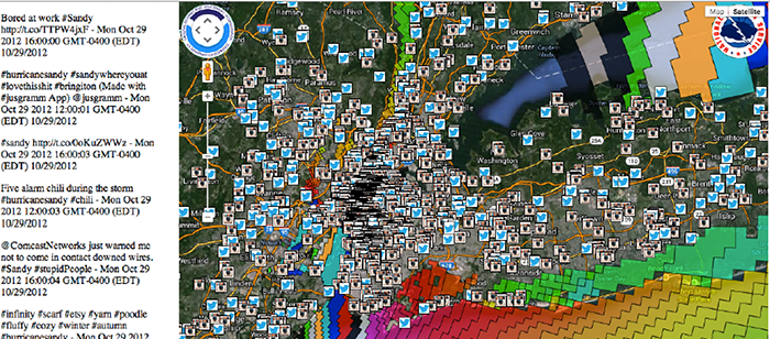
In the proposed approach, social media sources are viewed as a Human Sensor Network, and Social Media users are viewed as “human sensors” that are “deployed” in the field, and their posts are considered to be “sensor observations”. I have utilized the “human sensor observations”, i.e. data acquired from social media, as boundary value forcings to show improved geophysical model forecasts of extreme disaster events when combined with other scientific data such as satellite observations and sensor measurements. In addition, I have developed a system called ASON maps that dynamically combines model forecast outputs with specified social media observations and physical measurements to define the regions of event impacts such as flood distributions and levels, beached tarballs, power outages etc. Real time large datasets were collected, archived and are available for following recent extreme disasters events as use case scenarios.
In the case of the Deepwater Horizon oil spill disaster of 2010 that devastated the Gulf of Mexico, the research demonstrates how social media data can be used as a boundary forcing condition of the oil spill plume forecast model, and results in an order of magnitude forecast improvement. In the case of Hurricane Sandy NY/NJ landfall impact of 2012, owing to inherent uncertainties in the weather forecasts, the NOAA operational surge model only forecasts the worst-case scenario for flooding from any given hurricane. This dissertation demonstrates how the model forecasts, when combined with social media data in a single framework, can be used for near-real time forecast validation, damage assessment and disaster management. Geolocated and time-stamped photos allow near real-time assessment of the surge levels at different locations, which can validate model forecasts give timely views of the actual levels of surge, as well as provide an upper bound regional street level maps beyond which the surge did not spread. In the case of the Tohoku Earthquake and Tsunami of 2011, social media aspects of handheld devices such as Geiger counters that can potentially detect radioactive debris are discussed as well.
Committee: Dr. Milton Halem (chair), Tim Finin, Anupam Joshi, James Smith, Yelena Yesha